Gas Flaring and Biodiversity Depletion in Nigeria: A Study of Selected Gas Flare Sites in Rivers State, Nigeria
*Corresponding Author(s):
Bakpo MTDepartment Of Environmental Sciences, Captain Elechi Amadi Polytechnic, Port Harcourt, Rivers State, Nigeria
Tel:+234 8030332386,
Email:mosestonubari@gmail.com
Abstract
This study presents analysis of biodiversity depletion around some gas flare sites in Rivers State, Nigeria. The study specifically examined vegetation depletion around the gas flare sites. The study adopted field measurement for data collection. Five different sites were selected for the study including four gas flare sites and a control site. In each experimental site vegetation samples were obtained along transects established from the gas flare stacks outward. The data was obtained in a 10x10m quadrate placed at regular interval of 30m along the transects. A total of 60 quadrats (two transects per site). The study showed a variation in the vegetation frequency (number of species), number of families and density between the control and the gas flare sites. The study also revealed dissimilarity between species in the gas flare site and the control. On the basis of these, the study recommended among others, to stop flaring of gas and channel it towards small scale utilization through electricity.
Keywords
Biodiversity; Gas flare; Quadrats; Transects; Vegetation
INTRODUCTION
One of the major causes of air pollution is gas flaring. The gas is associated with crude petroleum when it is pumped up from the ground. Flaring was employed to dispose of this associated gas [1]. Available records showed that Nigeria has abundant reserves of natural gas estimated at over 100 trillion cubic meters qualifying the country to be one of the top 15 countries with proven gas reserves [2].
A gas flare site may have a number of stacks depending on the size of the flow station. Nigeria flares more gas than any other country in the world, most of it from the Niger Delta. This means that Nigeria has one of the worst rates of gas flaring in the world. For Rivers, Bayelsa and Delta States, around 12 million tons of methane are released into the atmosphere per year. However, studies have been carried out on the impact of gas flare on biodiversity, especially vegetation in the Niger Delta region of Nigeria. Biological diversity or Bio-diversity is the total variability within all living organisms and the ecological complexes they inhabit.
Humans depend on biodiversity because it is the human life support (the source of our food, medicines, timber fibre and many other products). Anthropogenic activities (gas flaring) have endangered most of this biological diversity. Studies have been carried out by researchers to determine the impact of air pollution arising from gas flaring which revealed negative effects of the former on species distribution and composition in the region [3-8]. Plants and indeed entire vegetation are known to exhibit physiological responses to environmental stress, such as temperature changes, tramping and contamination of air with high concentration of toxic gaseous and other particulate pollutants such as dust.
Thus understanding of such slower processes leading to damages and biodiversity loss becomes an integral essential pre-requisite to the sustainable utilization of vegetation resources. In Nigeria, very little attention has been focused on the disastrous impact of air pollutions on ecosystems. It is therefore obvious that the relationship between gaseous pollutants and vegetation could hardly be understood. An understanding of the problem of vegetation decay especially in the third world and Nigeria in particularly can only be reliably examined when the complimentary issue of gaseous pollution is allowed to offer a preliminary assessment of its importance relative to the other short term physical process such as bush burning.
This becomes necessary in view of the fact that the ecosystem of Nigeria is threatened by the worst form of degradation, a situation which is complimented by observations that Nigeria flares more gas than any other country in the world. Considering the dangers emanating from gas flaring on our environment, it therefore becomes expedient to carry out a proper investigation on its impact on plant species population around the gas flare gas sites. This phytosociological investigation becomes necessary in view of the fact the flaring of gas has been confirmed by researchers to be a factor of environmental degradation.
MATERIALS AND METHODS
Study area
Rivers State is located between latitude 4030l-5040lN and Longitude 6040l-7020lE. The state is located in the Niger Delta region of Nigeria, also known as the South-South geopolitical zone. The total land area of the state is approximately 10,378 square kilometers. It has as total population of 5,198,716 and a population density of 501 persons per square kilometer [9]. The State enjoys the humid tropical climate with a temperature average of 27°C. The annual range varies from 1°C to 3°C, while diurnal range is between 6°C and 8°C. Rainfall in the State could be described as seasonally variable and energetic in down pour [1].
Rain occurs every month of the year, but of varying duration. Primarily, rainfall is controlled by two air masses, the South-West monsoon which derives its origin from the sub-tropical high pressure belt over the Southern Atlantic Ocean. The other is the harmattan, an opposing air mass with a continental origin from the sub-tropical high pressure belt of the Sahara Desert. The soils of Rivers State have spatial characteristics. Therefore, they are grouped into six main classes. The coastal plain terrace, soils of the sub recent Niger Terrace, soils of the Fresh Water Alluvial zone, soils of the fresh/salt water transition zone, soils of the mangrove zone (tidal flats) and soils of the Beach-ridge zone.
The vegetation of Rivers State is the tropical rains forest divided into three principal types; mangrove swamp forest, fresh water swamp forest and moist or low land rainforest. Emejuru and Bakpo [10] have reported in their assessment, landscape change on settlement, water and land cover resources in Rivers State. The forest has variety of plant species which are of great importance to the environment. Each of the forest belts is endowed in resources but is presently under serious threat due to anthropogenic activities.
This variation in species richness and evenness may be attributable to environmental pollution. Solomon, George-West and Alalibo [11] revealed that negative impact of environmental pollution in the Niger Delta and its consequential challenges to sustainable development of the region and highlighted the role that can be carried out by the individual in pollution prevention and control (Figure 1).
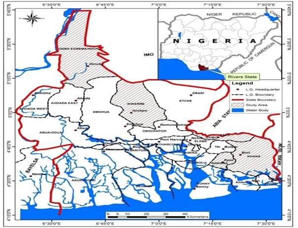 Figure 1: Study area in the map of rivers state.
Methods of study
Five different sites were selected for this study including a control. The active gas flare sites are located at Ebocha in Ogba/Egbema/Ndoni Local Government Area and Oyigbo North, in Oyigbo Local Government Area. The non-active flare sites are located at Bomu (K. Dere) in Gokana Local Government Area and Yorla (Kpean) in Khana Local Government Area. These sites were purposively selected because of ease of accessibility. A control site was selected at Igwuruta-ali in Ikwerre Local Government Area. The study sites showed spatial characteristics and are located within the same climatic and soil zone. In each experimental site, vegetation samples were obtained along transects established from the gas flare stacks outwards. The direction of the transects were determined by the dominant wind directions. Data was obtained in a 10 m by 10 m quadrate placed at regular interval of 30m along the transects from the flare stacks. A total of six (6) quadrats were sampled along each transect of 180m in length. Therefore, a total of sixty (60) quadrats were sampled, including the control. That is two (2) transects per site. The vegetation was sampled in the 10m by 10m quadrate regularly placed at 30 m interval along the transects established from the flare stacks outward. In each of the quadrats, vegetation species were counted noting the following:
- Number of species
- Number of family
- Species density
- Index of community similarity
Number of species: This was achieved through counting and identification of species in each quadrat for all the quadrats.
Number of family: The species families were achieved by identification of the species by a plant taxonomist.
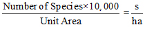
Species Density: This is the number of individual trees per unit area determined by simple count of the species in the quadrate.
Index of community similarity: This expresses the ratio of the actual number of species common to two or more vegetation segments being compared.
This index is computed as:

Where:
A = Total number of species in the first site.
B = Total number of species in the second site.
C = Number of species common to both.
RESULTS AND DISCUSSION
The result of vegetation analysis in table 1, show a variation analysis of species among the sites. The control site has a total of 22 species, Ebocha 13 species, Oyigbo 16 species, while Bomu and Yorla have 14 and 15 species respectively. The result clearly showed that the gas flare sites have less number of vegetation species compared to the control. This variation may be as a result of flaring of gas in the affected sites. The study also revealed that the number of species and families varies among the gas flare sites and the control. In the gas flare sites, Ebocha has eight (8) families, Oyigbo 13, Bomu 13 and Yorla 9 families; while control has 15 families. The study further revealed that control site has a vegetation density of 2200 species per hectare (s/h) while the gas flare sites at Ebocha have 1300 s/h.
|
Study Site |
Number of Species |
Number of Families |
Density s/h |
|
Control (Igwuruta-ali) |
22 |
15 |
2200 |
|
Ebocha |
13 |
8 |
1300 |
|
Oyigbo |
16 |
13 |
1600 |
|
Bomu |
14 |
13 |
1400 |
|
Yorla |
15 |
9 |
1500 |
Table 1: Summary of vegetation analysis in the study area.
Source: Bakpo [8].
This further shows that the high variation between the control and gas flare sites may be as a result of the flaring of gas in these sites. Results of similarity index show a variation between the communities. This was established between the communities. This was carried out between the control and the gas flare sites (Table 2).
|
Control and Ebocha |
Control and Oyigbo |
Control and Bomu |
Control and Yorla |
|
28.6% |
53.7% |
38.9% |
64.1% |
Table 2: Index of community similarity between control and the gas flare sites.
Source: Bakpo [8].
The study established that there was dissimilarity between the community composition of Ebocha gas flare site and the control (28.6%). The study also indicates that the vegetation community in Oyigbo was closely similar to the control (53.7%). Bakpo and Solomon (2018) have earlier demonstrated the relationship between soil and vegetation in oil and gas polluted environment as revealed by regression analysis and this findings corroborated with their observation.
The community of Yorla site and control were closely similar (64.1%). This similarity and dissimilarity between control and the gas flare sites is an indication that gas flaring has impacted seriously on the surrounding vegetation. Rilwani and Emejuru [12] had reported the negative effect of changing landuse/Landcover pattern on traditional farming system in the upper Niger Delta Region of Rivers State, Nigeria.
After collection and analysis of data, the summary of the results obtained for vegetation analysis in the study area is presented in table 1.
CONCLUSION AND RECOMMENDATIONS
Conclusion
The study has shown that gas flaring has affected vegetation composition in terms of species richness, dominance and density. The study reveals variation in number of species in the control and the gas flare sites a total of eighty (80) species from sixty quadrats in five (5) sites, with the control (Igwuruta-ali) having the highest number of species (22), Oyigbo and Yorla gas flare sites has sixteen (16) and fifteen (15) species respectively.
Bomu and Ebocha gas flare sites have fourteen (14) and thirteen (13) species respectively. The index of community computed showed dissimilarity in species composition between the gas flare sites and the control. The analysis shows that there is a significant difference between species composition in the gas flare sites than the control. This difference could be attributed to gas flare and anthropogenic activities.
Recommendations
Considering the role vegetation plays in our environment and the level of its depletion as a result of anthropogenic activities, this study strongly recommends the following:
- There is urgent need to stop the flaring considering its threat to the environment.
- The gas can be channeled for small scale utilization such that it benefits the local communities. This can be done through electricity production (gas turbine) and re-injecting the gas into the oil field to enhance oil recovery.
- The fines paid by oil companies for flaring should be increased from $3.50 for every 1000 standard cubic feet paid from 2008 to an amount that will be reasonable in order to discourage them from flaring gas.
- There should be conservation – oriented economy and not one which self-exciting entrepreneurs is the driving force.
- There is need for environmental awareness in the country. This will help citizens to have good information on the dangers that would arise from anthropogenic activities.
- There is need for environmental monitoring and auditing.
- Finally, the study recommends strongly, campaign aimed at the youths of the study area who engage in bunkering and illegal refining of crude oil to stop.
REFERENCES
- Ede PN (2011) Ending gas flaring in Nigeria: Challenges and prospects, paper presented at the Port Harcourt international oil and gas conference and exhibition at the main auditorium, Rivers State House of Assembly Complex, Port Harcourt, Nigeria
- Kadana REL (1993) The gas industry Nigeria Ompadec Rep. 1: 90-96.
- Odu CTI, Adedipe NO, Spiff ED (1976) Determination on the agronomic effects of gas flares. Nigeria Agip Oil Company, Port Harcourt, Nigeria.
- Fowler FTLD, Freer-Smith PH (1985) Effects of air pollutants on agricultural crops. Institute of Terrestrial Ecology, Huntingdon, England.
- Okoh NV (2000) Environmental impacts of oil exploration. Atmospheric Review, 12: 68-80.
- Obi CJ (2001) The oil sector and sustainable environment. Environmental Knowledge, 13: 1-18.
- Odjugo PAO (2004) The impact of gas flaring on atmospheric quality: The case of niger delta, Nigeria. International Journal of Ecology, Environmental Dynamics 2:12-33.
- Bakpo MT (2015) Analysis of soil and vegetation degradation around some gas flare sites in rivers state, Nigeria. University of Uyo, Uyo, Nigeria.
- NPC (2006). Report of Nigeria's national population commission on the 2006 census. National Population Commission, Nigeria.
- Emejuru SA, Bakpo MT (2019) Assessment of landscape change on settlement, water and land cover resources in rivers state, Nigeria. Journal of American Science, 15:70-77.
- Solomon L, George-West O, Alalibo IK (2017) Environmental pollution in the Niger Delta and consequential challenges to sustainable development of the region: the role of an individual. Researcher, 9: 10-15.
- Bakpo MT, Solomon L (2018) Relationship between soil and vegetation in an oil and gas polluted environment as revealed by regression analysis. Journal of Petroleum and Environmental Biotechnology 9: 385.
Citation: Bakpo MT, Emejuru SA (2019) Gas Flaring and Biodiversity Depletion in Nigeria: A Study of Selected Gas Flare Sites in Rivers State, Nigeria. J Environ Sci Curr Res 2: 011.
Copyright: © 2019 Bakpo MT, et al. This is an open-access article distributed under the terms of the Creative Commons Attribution License, which permits unrestricted use, distribution, and reproduction in any medium, provided the original author and source are credited.