App Design Made Easy: Locandy.com Content Management System is an Appropriate Programming System for Location-Based Gamification Apps to Design Citizen Science Projects in Zoology
*Corresponding Author(s):
Thorsten SchwerteHead Of Department Zoology, Institute Of Zoology, University Of Innsbruck, Techniker Str. 25, A-6020 Innsbruck, Austria
Tel:004351250751862,
Email:thorsten.schwerte@uibk.ac.at
Abstract
The main drive for users to participate in citizen science projects is the motivation to learn something new and to be part of the creation process to establish new knowledge.
Location-based gamification is a modern strategy, which applies game-design elements and game principles in non-game contexts. It utilizes a human’s natural tendency to participate in games and competitions. This brought us to the idea that scientist guided structured data acquisition for citizen science projects can be designed using an easy-to-use content management system (CMS).
We evaluated existing products for the design of GPS (global positioning system) location-based adventure-like paths and evaluated the usability to teach life science, sports, health knowledge by generating appealing smartphone apps. We tested different web-based application design tools for structured data acquisition and user education and decided on Locandy.com, because of its main strengths over others: the possibility to use variables and the ability to encode more complex algorithms to support scientific projects. It was shown that even complex teaching matters were successfully presented using this CMS and location-based gamification in an outdoor environment proved to be an efficient teaching strategy. Furthermore, it was shown that the integration of nature has the capability to teach complex interdisciplinary knowledge connections and helps to design data acquisition apps even for non-coding scientists.
Keywords
Citizen Science; Content management; Location based gamification; Science communication
INTRODUCTION
Citizen science (CS) as a means of communicating science, engaging the public and do research in a modern and appealing way has become the focus of great hopes and expectations over the last decade. It can be seen as a win-win scenario, where scientists get support from the public and participants to get knowledge in the scientific method and their environment. It is public engagement and research that includes them in a real and meaningful scientific investigation. Scientists often see CS, mainly referring to the US understanding of the term, as an idea that successfully combines public engagement and outreach objectives with the scientific goals of scientists themselves [1]. Furthermore, CS is scientific research performed, in whole or in part, by amateur (or non-professional) scientists. A discussion toward an international definition of citizen science is discussed by Heigl et al (2019) [2]. CS is interpreted in different ways and takes different forms with varying degrees of involvement [3]. In addition, the CS mark is currently assigned to research activities either by project principal investigators (PIs) themselves or by research funding agencies. In this context, influential critics of CS have drawn attention to important legal and ethical concerns [4], including intellectual property [5] and scientific integrity [6].
Although CS appears to be an economic way of conducting field data acquisition, there is a methodological, epistemological and ethical discussion among scientists. Although most scientists are enthusiastic about the CS method, publishing their data often turned out to be difficult because of data quality issues [7].
A number of professional networks for CS stakeholders have already been established, such as the US-based Citizen Science Association, the European Citizen Science Association, and the Australian Citizen Science Association. Currently, there is an increasing amount of CS projects, most of them being organized and made available through CS web-based platforms (for examples see Table 1). Many projects listed there include well-developed information material, print media and/or make the use of proprietary smartphone applications. In order to ensure data acquisition of high reproducibility and quality, precise instructions of the participants are imperative. This includes that participants have to be highly motivated to do their best and to be willing to learn new techniques and knowledge. Many citizen science projects took part in the digital transition and omnipresent smartphones serve as a technical platform to provide both: non-scientist training and data acquisition routines. Typical examples are: The First Peninsular Malaysia Butterfly Count [8]; Effects of Natura 2000 on nontarget bird and butterfly species based on citizen science data [9]; Using mobile phones as acoustic sensors for high-throughput mosquito surveillance [10]; Amphibian and reptile road?kills on tertiary roads in relation to landscape structure: using a citizen science approach with open?access land cover data [11] or Fox sightings in a city are related to certain land use classes and sociodemographics: results from a citizen science project [12].
|
Platform |
Weblinks |
Characteristic / Functionalities |
|
|
Buergerwissenschaften |
A central platform for Citizen Science in Germany for launching, networking and supporting Citizen Science projects (since 2013). The Citizen Science Forum is organizing an important networking event for citizen research in the German-speaking countries. |
||
|
Citizen-Science.at |
Austrian citizen science platform that launches, organizes and hosts projects and organizes a yearly conference. The platform is organized by the Institute of Zoology Department of Integrative Biology and Biodiversity Research University of Natural Resources and Life Sciences, Vienna |
||
|
Citizen Science Platform of the European Commission |
The European Citizen Science Platform gives every citizen the opportunity to contribute to European policy making. It is a customizable tool to facilitate data collection, in particular by supporting citizens ' contributions. The inputs received are used to broaden the evidence base for European policies. In this way, future policy debates will not only be supported by scientific advice from a few selected experts, but can also benefit from targeted contributions from the citizen. |
||
|
Zooniverse |
A huge and popular human-powered research platform, made possible by volunteers around the world to assist qualified researchers. Typical research results are new discoveries, databases that are valuable to the broader research community. |
||
|
Citizen Science Today |
A platform that features (not organizes) citizen science projects with information from several sources. |
||
|
Citizen-Science.gov |
An official website of the United States Government with a forum for promoting the use of crowdsourcing and citizen science across the U.S. government. The site provides a gateway to three key components: a database of federally funded citizen science initiatives, a toolkit to assist federal practitioners in planning and managing their projects. |
||
|
CitizenScience.org |
CitizenScience.org aims to harness the knowledge gained by practitioners and researchers across the field of citizen science in order to build collaboration, community and credibility. |
Table 1: Examples of international citizen science platforms that are used to offer, promote and organize citizen science projects.
In the last decade gamification as a motivational strategy in making people participate in CS projects. Gamification has been shown to be an appropriate tool for user engagement in different topics, like e.g. medical, biological, pharmacy, mental health, cardiorespiratory fitness or scientific thinking [13-18]. Programming individual smartphone applications with gamification capabilities need smart programmers. Researchers complain about the tremendous costs that come up with the use of these technologies and hire programmers to be part of the project [19]. Although this decrease costs the need for a versatile method to generate gamification apps for the experimental design of CS data acquisition made us testing a modern, easy-to-use content management system (CMS) instead of paying a programmer for coding a proprietary application. This study was designed to test the available field-based content management systems that are capable of educating and enthralling citizens to engage in structured data collection for scientific research. In addition, the system should include guidance capabilities using GPS (global positioning system) and some kind of programming mechanism to apply gamification-driven data collection.
METHODS
For a preliminary study to check the available content management systems, we wrote a conceptual design for local mosquito species monitoring that explains the scientific question, uses storytelling to fascinate the participants, explains how to create a mosquito trap and guides to a typical mosquito habitat. We searched the web for available systems that contain the following keywords (German and English): field guide, scavenger hunt, gamification, outdoor, edutainment, content management, audio guide and mobile app. We evaluated the results for our needs to design a citizen science project (see above).
RESULTS
The web search revealed 27 different content / app providers and potential field-based content management that are capable of educating and enthralling citizens to engage in structured location based data collection for scientific research. The results of the testing of these offers for guidance purposes such as the use of the GPS and some kind of programming mechanism (at least variables, conditions, arithmetic’s and comparisons) for the application of gamification-driven data collection are summarized in Table 2. Twelve offers were companies offering full-service app programming without the option of self-management of content. These twelve included four audio-only design services (typical audio guides). Fifteen offers had a customer-enabled content management system with two of them offering a free plan for an unlimited number of clients (citizen scientists).
|
Name |
Weblinks |
Field Guidance |
Gamification |
Edutainment |
GPS |
CMS |
Multimdia A/V |
Programming language |
Free for unlimited number of clients |
|
Cluetivity |
y |
y |
y |
y |
n |
y |
n/a |
n |
|
|
Logquiz |
y |
y |
y |
y |
y |
y |
n |
n |
|
|
Social Scavenger |
y |
y |
y |
y |
y |
y |
n |
n |
|
|
Actionbound |
y |
y |
y |
y |
y |
y |
n |
n |
|
|
Goosechase |
y |
y |
y |
y |
y |
y |
n |
n |
|
|
Huntzz |
y |
y |
y |
y |
y |
y |
n |
n |
|
|
Scavr |
n |
n |
n |
y |
y |
y |
n |
n |
|
|
Scavify |
y |
y |
y |
y |
y |
y |
n |
n |
|
|
Eventzeeapp |
y |
y |
y |
y |
y |
y |
n |
n |
|
|
Espoto Treasure Hunt |
y |
y |
y |
y |
y |
y |
n |
n |
|
|
Mooveteam |
y |
y |
y |
y |
y |
y |
n |
n |
|
|
TAZ Team Action Zone |
y |
y |
y |
y |
y |
y |
n |
n |
|
|
Xnoteapp |
y |
y |
y |
y |
y |
y |
n |
n |
|
|
Locandy |
y |
y |
y |
y |
y |
y |
y |
y (only non-commercial) |
|
|
Oroundo |
y |
y |
y |
y |
n |
y |
n/a |
n |
|
|
GPS Fit |
y |
y |
y |
y |
n |
y |
n/a |
n |
|
|
Lauschtour |
y |
y |
y |
y |
n |
n (audio only) |
n/a |
n |
|
|
Ort und Ton |
http://ort-und-ton.com |
y |
y |
y |
y |
n |
n (audio only) |
n/a |
n |
|
IZI Travel |
https://izi.travel/de |
y |
y |
y |
y |
y |
y |
n |
y (only non-commercial) |
|
Geheimpunkt |
http://www.geheimpunkt.de |
y |
y |
y |
y |
n |
y |
n |
n |
|
Kundenschatz |
https://kundenschatz.de |
y |
y |
y |
y |
n |
y |
n/a |
n |
|
Myspot |
https://www.myspots.city |
y |
n |
y |
y |
n |
y |
n/a |
n |
|
Guidemate |
https://guidemate.com |
y |
n |
y |
y |
n |
n (audio only) |
n/a |
n |
|
Stadt im Ohr |
https://www.stadt-im-ohr.de |
y |
n |
y |
y |
n |
n (audio only) |
n/a |
n |
|
Apptec |
https://apptec.at/leistungen/ |
y |
y |
y |
y |
n |
y |
n/a |
n |
|
NOUS |
y |
y |
y |
y |
n |
y |
n/a |
n |
|
|
Tonwelt |
https://www.tonwelt.com/en/ |
y |
y |
y |
y |
n |
y |
n/a |
n |
Table 2: List of content providers and potential field-based content management systems (CMS) that are capable of educating and enthralling citizens to engage in data collection for scientific research. In addition, the offers were tested to have guidance capabilities using a global positioning system (GPS) and some kind of programming mechanism (at least variables, conditions, arithmetics and comparisons) to apply gamification-driven data collection. In-Table abbreviations y=yes; n=no; n / a=not applicable.
IZI Travel, Actionbound and Locandy provide an interactive GPS or QR code CMS for guided tours (English and German versions) [20,21]. IZI Travel focuses on audio guides with additional videos, images and quizzes. Actionbound is a CMS for training tours with videos, images, quizzes and exercises. Locandy is a CMS with videos, photos, quizzes, exercises and many more features (including programming elements such as variables, comparisons and conditions) that make it capable of developing citizen science projects with more complex algorithms to support scientific projects. We analyzed the characteristics of the locandy and summarized them in Table 3.
|
Field Navigation Tools |
Media Tools |
Gamification Tools |
Real World Sensing |
Data Acquisition |
Programming |
|
GPS |
Audio-Plugin |
Multiple-Choice |
QR Codes |
GPS-tagged Photo |
Variables |
|
Map |
Video-Plugin |
Text Match |
iBeacon |
GPS-tagged Video |
Comparison |
|
Direction Arrow |
Foto-Plugin |
Image Riddle |
NFC |
GPS-tagged audio |
Conditions |
|
Compass |
Text-Plugin |
Image Search |
Bluotooth Low Energy |
Smartphone Sensors |
Multiple GUI |
|
Open external URL |
Submenues |
Inventory |
GPS |
Digital Forms |
Agent Dialogue |
|
Results |
Analog Forms |
Branching |
|||
|
Badges |
Score Sheets |
||||
|
Agent |
Agent |
||||
|
Virtual Items |
Table 3: List of Field Navigation Tools, Audio Tools, Web Tools, Real World Sensing and Data Acquisition Tools in the Content Management System (CMS) Locandy. The properties mentioned do not necessarily have the same name in CMS but are similar to the terms of programming mechanisms and technical properties used in the scientific workflow. GUI=Graphical User Interface.
DISCUSSION
There are a number of companies available on the web that offer a smartphone application program service to meet your needs. Spotteron (https:/www.spotteron.net/) is a fully customizable and affordable solution for your Citizen Science, Environmental Protection and Voluntary Monitoring initiatives. The objective of Spotteron is monitoring, which means the unstructured acquisition of observations produced by the consumer. In contrast to this, we analyzed web services and evaluated products that enable the acquisition of structured data. Structured data can come from observations, experimental manipulations or measurements made at a particular GPS location. From the list of 27 different services on the market, Locandy was chosen because of its main strengths over others: the ability to use variables and the ability to encode more complex algorithms to support scientific projects. Locandy was not intentionally designed to host scientific projects, but its features meet all the needs for them. Untypical for a discussion, we decided to give some advice on how to get the most out of Locandy to make your next citizen science project successfully supported by a smartphone app.
Although the Locandy User Manual (German) contains detailed instructions on how to make a good adventure for a wide range of audiences, you will not find any details on how to digitally transform your citizen science data acquisition needs with a scientific user guide. Finally, we will present a best-practice example of how we planned our next Citizen Science Project on Mosquito Monitoring and Awareness before we end with concluding remarks.
SCIENTIFIC USER GUIDE
Locandy.com content management system for CS location-based data acquisition and user education
Locandy.com is a CMS with a web-frontend that works with the internet browsers Safari and Chrome. The limit on these two browsers has security reasons. Users/consumers of your created content can use any browser, IOS and android phones). In order to edit quests, you need to register with your Twitter, Facebook or Google account, alternatively with a free choice of username and password. To date, the homepage is in German, the web-frontend language (after login with your user credentials) is changed to English when the browser settings are set to different languages than German. To receive author rights, you can send an email to office@locandy.com. For non-profit or non-commercial applications, the use of Locandy is free of charge.
Locandy includes a Mixed-Reality-Media Player (MRM-Player) for smartphones that can be used to show almost any location-based content and interactions to different audiences. You (and your participants) can download the MRM-Player for free in the Google android Playstore (Figure 1) or in the Apple Appstore. The user of Mixed Reality Interaction chooses multiple locations in the real world and the device provides an additional virtual state for each place in the real world plus one for the user or player. In this way, the MRM-Player replicates the virtual equivalent of the real world and provides a platform for rich interactions. The researcher (author) provides the user with material (text, audio, interactions) at each venue.
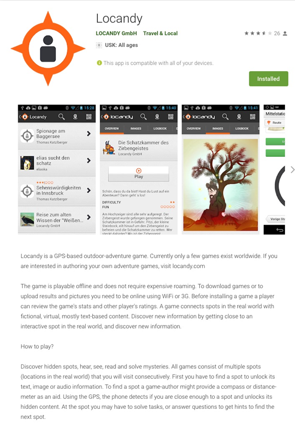 Figure 1: Information about the Locandy mixed reality player in the Google Playstore (2020).
The user sees the MRM-player bundled in an iPhone or Android App and installs a CS Project (including text, audio, and images). Upon reading a short teaser and navigating to the beginning of the individual CS Projects, the MRM-Player is started by the user. The user can unlock further information on one or more specific aspects of your CS project by unlock codes (e.g. QR codes) before he starts navigating to the first sampling site.
Interaction with the virtual world begins when the user enters the vicinity of the first station/spot (e. g. more than 30 m) where the content of the station/spot is enabled and the user can read and communicate with the virtual world. Figure 2 shows an example of how you can assign a real-world spot in the Locandy CMS. Users adjust the virtual world by using keys, answering multiple-choice questions, entering words, or using virtual inventory objects. All of these activities trigger complex effects with optional pre-conditions; all crafted by the author; to alter the virtual world and player states. Effects can display messages, alter local or distant, visible or invisible states, play audio and background sounds, hide and remove components and text parts. All of this can be used to steer the interaction of the user with the real world (e. g. performing experiments and/or doing measurements).
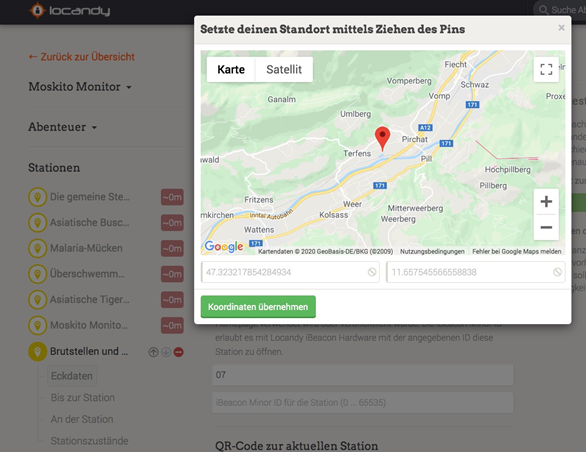 Figure 2: Example of the "Click Location" function. Stations/spots can be located in the real world using the google maps service. This is an alternative to putting QR codes on objects.
After this short summary of what Locandy can do for CS projects, recommendations are given on how to develop good mixed reality media.
Keeping in mind that originally Locandy was developed for the implementation of interactive adventure trails with a radio play character it is good to know that a combination of storytelling, gamification, and edutainment makes a good storyboard and setting for CS projects. It helps you to incorporate the participants in the living environment of your study.
Which elements make Locandy the right tool four your next Zoology CS project?
In Locandy, you can focus on the important things that have made other CS ventures popular without the need to be a professional programmer: gamification, storytelling, edutainment/training and data acquisition. The primary units of your project workflow are so-called "stations" or “spots” that can be assembled in any order. Every CS project needs excellent media, with Locandy you can transform them into an appealing smartphone app.
Gamification-enthusiasm with ease
Playful elements arouse the excitement of exploration within us. Gamification is the transition of game-typical features to systems that are not normally connected to the game in order to improve motivation. Locandy also uses elements that allow for the use of awards or experiences to make the CS project's multimedia guide even more engaging and interactive for users. You can use text or even better radio play encounters that are processed with a game mechanism so that discovering the world is even more enjoyable and users can explore it with all their senses.
Storytelling-funny and informative tales
Storytelling is a key element in our daily communication. There's a lot of potential in good stories. They motivate, share knowledge and experience, reduce complexity and organize our world, among other things. Locandy combines the storytelling method with gamification and location-based services in a variety of interactive themed trails. The stories are told on the spots/stations. They draw attention to the peculiarities of the environment and share knowledge. They are designed to arouse emotions and astonish, inspire and appeal to the listener. Your exercise is to make clear why your research topic is important, what does it mean to the user, to people, to the world. This makes it more likely that your participants collect useful data.
Edutainment-Entertaining knowledge transfer
Storytelling and gamification enhance the excitement and encouragement of learning. Locandy's immersive media experiences motivate as they combine entertaining and informative entertainment with playful learning. Users are guided to specific locations. They need to travel consciously, and they can discover their surroundings and/or installations you have prepared for them with all their senses. The prepared adventure trail provides information and enhances users' understanding of nature, culture, and history in order to preserve them. You actively integrate them into your world of science. You transfer your fascination in deciphering the secrets of nature into them to make them your partner for the most important challenge-the data acquisition. Here you have to train the user: What does he need to know to understand the bigger context, why is HIS data important?
Here, you also can test the user. Did he understand the scientific method and the measurements that are asked to be done? Figure 3 gives an example of how easy a multiple-choice exercise can be integrated into a training spot/station.
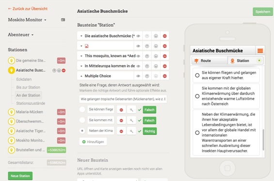 Figure 3: Definition of station/spot programming in the content management system Locandy with a web-based interface in the Google Chrome browser. The station layout is shown on the left side. An example of variable code blocks including a multiple-choice block with one question and three answer options is shown in the center. On the right, the resulting view is simulated on a smartphone in a simulated mixed reality player. Simulation is useful for testing and debugging content and gaming mechanisms.
Data Acquisition
After you have trained your participants well, you can send them to different real-world locations (as easy as shown in figure 2) and have them obtain specific data sets that are sent to you after the search has been completed. The gaming system makes it very likely that the same user will enter one of your next quests. Locandy's modular capabilities make it easy for you to design new stations for the following data acquisition sites. Figure 4 shows an example of the CMS web-frontend with different stations/spots on the left, the modular setup of the information and the simulation preview on the right. Many current CS Projects acquire unstructured data, which means that users grab data on any place they like or make observations. This often leads to biased data, because users report events that are most probable to observe. For example, in the CS project, Roadkill (https://roadkill.at/) people report animals that have been killed on roads. However, this also includes the collection of data on sites where users decide on. This leads to unstructured data. Some of these projects are hosted on https:/www.spotteron.net/ with a fully customizable and affordable solution for your Citizen Science, Environmental Protection and Voluntary Monitoring projects. The company supports CS programs focusing on voluntary monitoring of free-chosen sites within the project boundaries. In comparison to this, Locandy gives you the opportunity to allow users to collect structured data on the platforms that you choose, with highly flexible frameworks for setting up individual gamification.
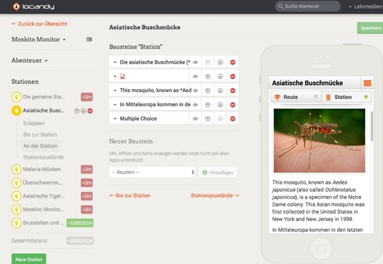 Figure 4: Example of station/spot programming in the content management system Locandy with a web-based interface in the Google Chrome browser. This is an example of a description of the species Ochlerotatus japonicus. The station structure is shown on the left side. An example of variable code blocks, including an image and several text blocks, is shown in the middle. On the right, the resulting view is replicated on a smartphone in a virtual mixed reality game.
Variable building blocks for content gamification and data acquisition mechanism
For your programming workflow in the Locandy CMS, you have variable building blocks that support your education, user guidance, and data acquisition tasks. These are listed in Table 3 and some of them can be seen in figure 4.
The CMS contains a linear workflow with easy-to-use forms for your project’s homepage, the individual training units, sampling sites, and result reporting. Figure 5 describes the general workflow for a gamification CS Project, while figure 6 shows the overall structure, variables, and contents in the whole project organization of the CMS. Sometimes structured data acquisition and gamification contents need a whole bunch of variables. During testing and “debugging” of your CS media, a complete list of all variables together with their contents is listed below the smartphone simulation (Figure 7).
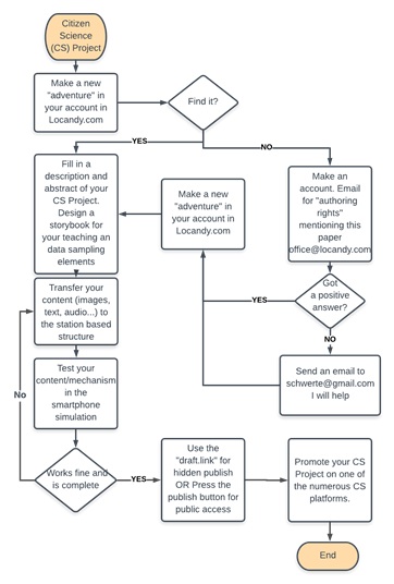 Figure 5: A typical workflow of the planning and programming of a citizen science project is shown in a schematic drawing.
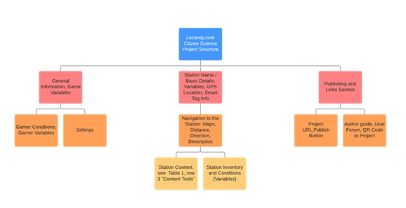 Figure 6: The simplified and abstracted project structure of the Locandy Content Management System (CMS) is shown. The order from left to right is not the same as the order from top to bottom in CMS, but is in order to prepare and publish the document. The charts are made with the free version of https://www.lucidchart.com/. Lucidchart is a useful web-based tool for planning and visualizing workflows and processes.
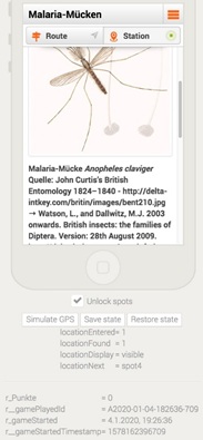 Figure 7: Example of station/spot programming in the content management system Locandy with a web-based interface in the Google Chrome browser. Tools are available on a virtual smartphone with a standard debugging and information mixed reality games. This is a checkbox for unlocking a station/spot in a simulation without scanning a QR code or unlocking it at a specific GPS location. Three radio buttons are used to simulate the location of the GPS, save and restore the position of the spot. This is accompanied by a list of the quest programming variables.
Where to go from here-How to create your first CS Data Acquisition
It is highly recommended to set up a storyboard for the storytelling and instruction part or at least a flow chart like shown in figure 5 for every station/spot and the general project contents. You have to decide on what budget you have to include for your media production (figures, animations, test, audio, forms, and tests). It can be a lean production which means you do all the artwork on your own. Or you can outsource some part to professional designers which makes your project more expensive. Then you can start to transfer your content into the Locandy CMS. A side-by-side smartphone simulator lets you test your growing application until you can finally publish it. Here you can also test the gaming mechanism. To have an overview of your variables you can look them up changing during using your simulated application under the smartphone simulation. After that, you should start promoting your project to attract future users and partners (Figure 5).
OUTLOOK: CITIZEN SCIENCE PROJECT: MOSQUITO AWARENESS AND MONITORING
In this project, we want to use gamification as a modern and motivating teaching strategy. Here we want to utilize gamification to motivate people to engage in citizen science projects. Public awareness of the importance of mosquito-borne diseases and the acquisition of data with citizen scientists is realized with a smart device app. Knowledge texts, videos, and audios provide knowledge on the ecology and vector competence of mosquitoes that communicate expertise in a playful and engaging manner. Outdoor breeding sites or traditional mosquito habitats are included to teach the ecology of mosquitoes with all senses. Appealing storytelling, incentives, and engaging media inspire citizens to take part in sampling and learn about the distribution of mosquito species. The project is ideal for anyone interested in mosquitoes and their health hazards. For public schools and minor people, a "Class mode" addresses school classes of all ages. While keeping the edutainment content and awards different monitoring sites will be explored. The media can easily be adapted to other locations in the world and/or mosquito and study problems.
The main content and structure of this media is:
Educational Indoor Stations:
• Biodiversity training
• Life cycles
• Diseases
• Prevention
• How to build a trap
GPS-Guided Outdoor Education:
• Breeding sites
• Habitats
• Experiments with mosquito sounds
• Experiments with mosquito flight
• Mosquito behavior
GPS-Guided Mosquito Sampling:
• Various sampling sites
• Home sampling
• Points and awards for participation
This project was presented at the 5th Austrian Citizen Science ul>Conference in Obergurgl (Austria, Tyrol) and will start in May 2020 [22].
CONCLUSION
The CMS Locandy is an appropriate tool for structured CS projects, because it combines edutainment for the training of the citizen scientist and spot/station based flexible programming to steer structured data acquisition of monitoring. Although complex algorithms can be encoded, programming is easy, because of its straight forward workflow and modular structure.
ACKNOWLEDGMENTS
Locandy can be used free of charge for non-commercial purposes, and is available at www.locandy.com. Research and Development were funded by the Austrian Research Promotion Agency (FFG). Our mosquito project is funded by the Tyrolean Research Fund (Tiroler Wissenschafts Förderung).
REFERENCE
- Silvertown J (2009) A new dawn for citizen science. Trends Ecol Evol 24: 467-471.
- Heigl F, Kieslinger B, Paul KT, Uhlik J, Dörler D (2019) Opinion: Toward an international definition of citizen science. Proc Natl Acad Sci USA 116: 8089-8092.
- Finke P (2014) Citizen Science?: das unterschätzte Wissen der Laien. Mit einem Nachw. von Ervin Laszlo. oekom-Verl, München.
- Guerrini CJ, Wexler A, Zettler PJ, McGuire AL (2019) Biomedical Citizen Science or Something Else? Reflections on Terms and Definitions. Am J Bioeth 19: 17-19.
- Guerrini CJ, Lewellyn M, Majumder MA, Trejo M, Canfield I, et al. (2019) Donors, authors, and owners: how is genomic citizen science addressing interests in research outputs? BMC Med Ethics 20: 84.
- Guerrini CJ, Majumder MA, Lewellyn MJ, McGuire AL (2018) Citizen science, public policy. Science 361: 134-136.
- Riesch H, Potter C (2014) Citizen science as seen by scientists: Methodological, epistemological and ethical dimensions. Public Underst Sci 23: 107-120.
- Wilson JJ, Jisming-See SW, Brandon-Mong GJ, Lim AH, Lim VC, et al. (2015) Citizen Science: The First Peninsular Malaysia Butterfly Count. Biodivers Data J 11: e7159.
- Pellissier V, Schmucki R, Pe'er G, Aunins A, Brereton TM, et al. (2019) Effects of Natura 2000 on nontarget bird and butterfly species based on citizen science data. Conserv Biol.
- Mukundarajan H, Hol FJH, Castillo EA, Newby C, Prakash M (2017) Using mobile phones as acoustic sensors for high-throughput mosquito surveillance. ELife 6: e27854.
- Heigl F, Horvath K, Laaha G, Zaller JG (2017) Amphibian and reptile road-kills on tertiary roads in relation to landscape structure: using a citizen science approach with open-access land cover data. BMC Ecol 17: 24.
- Walter T, Zink R, Laaha G, Zaller JG, Heigl F (2018) Fox sightings in a city are related to certain land use classes and sociodemographics: results from a citizen science project. BMC Ecol 18: 50.
- Latham B, Poyade M, Finlay C, Edmond A, McVey M (2019) New Tools in Education: Development and Learning Effectiveness of a Computer Application for Use in a University Biology Curriculum. Adv Exp Med Biol 1138: 29-46.
- Felszeghy S, Pasonen-Seppänen S, Koskela A, Nieminen P, Härkönen K, et al. (2019) Using online game-based platforms to improve student performance and engagement in histology teaching. BMC Med Educ 19: 273.
- Cain J, Piascik P (2015) Are Serious Games a Good Strategy for Pharmacy Education? Am J Pharm Educ 79:47.
- Cheng VWS, Davenport T, Johnson D, Vella K, Hickie IB (2019) Gamification in Apps and Technologies for Improving Mental Health and Well-Being: Systematic Review. JMIR Ment Health 6: e13717.
- Mora-Gonzalez J, Pérez-López IJ, Delgado-Fernández M (2019) The ‘$in TIME’ Gamification Project: Using a Mobile App to Improve Cardiorespiratory Fitness Levels of College Students. Games Health J.
- Morris BJ, Croker S, Zimmerman C, Gill D, Romig C (2013) Gaming science: the ‘Gamification’ of scientific thinking. Front Psychol 4: 607.
- Geyer K, Ellis DA, Piwek L (2019) A simple location-tracking app for psychological research. Behav Res Methods 51: 2840-2846.
- Digitale Erlebnisse mit Storytelling, Gamification und Edutainment, Locandy.
- https://de.actionbound.com/
- https://www.uibk.ac.at/projects/citizenscience/konferenz2019/programm.html
Citation: Schwerte T (2020) App Design Made Easy: Locandy.Com Content Management System is an Appropriate Programming System for Location-Based Gamification Apps to Design Citizen Science Projects in Zoology. Archiv Zool Stud 3: 012.
Copyright: © 2020 Thorsten Schwerte, et al. This is an open-access article distributed under the terms of the Creative Commons Attribution License, which permits unrestricted use, distribution, and reproduction in any medium, provided the original author and source are credited.