Seismic-sedimentary Facies Analysis of Es3x Formation in Southern Region, Laizhou Bay Depression, Bohai Bay Basin, China
*Corresponding Author(s):
Xie JunCollege Of Earth Science And Engineer, Shandong University Of Science And Technology, Qingdao, China
Email:xiejun0532@163.com
Abstract
Keywords
Laizhou bay sag; Mixed deposits; Sedimentary facies; Seismic facies; Seismic attribute
INTRODUCTION
BASIC GEOLOGICAL FEATURES
The tectonic evolution of Laizhou bay Sag in Bohai bay Basin is mainly influenced by the four stages of tectonic activities. Cenozoic strata are well developed in the study area. The main oil-bearing strata are Shahejieformation, especially Es3x formation, which is revealed by drilling data. From top to bottom of stratum is Nm formation, Ng formation, Ed formation, Es formation. The lithology of Nm formation is medium sandstones, fine sandstones and mudstones. The lithology of Ng formation is medium sandstones, grits and mudstones. The lithology of Ed formation is fine sandstones and mudstones. The lithology of Es formation is siltstones, fine sandstones and mudstones. The color of siltstones and fine sandstones is light grey. The color of mudstones is gray. On the whole, it is a set of sedimentary sequence from semi-deep lake to shore-shallow lake delta [2], the sedimentary range gradually becomes larger from small, and the shoreline gradually recedes(Figure 2A). In the middle well areas of Y3, Y4 and Y5 wells, terrigenous clastic and carbonate mixed sediments are developed. Sand and gravel bodies are the main favorable reservoirs and typical mudstone reservoirs (Figure 2B).
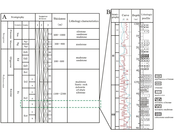 Figure 2: Comprehensive stratigraphic section of the southern region in Laizhou bay Sag.
SEISMIC FACIES ANALYSIS OF ES3X FORMATION
Seismic facies analysis
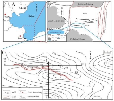
According to the north-south seismic profile EF of well Y5 in the research area (Figure 3 and the profile position is shown in figure 1C), obvious foreset and truncated reflection structures can be seen in the profile, which is speculated to be a delta sedimentary environment [8-9], and the overall formation is thinning to the south, indicating that a south-to-north provenance sedimentary system near the profile. By analyzing the characteristics of the seismic profile MN in Es3x Formation of the study area, it is found that both parallel-subparallel reflection structures and fore-integrating reflection structures (Figure 4 and the position of the section is shown in figure 1C). In other sections, the characteristics of seismic facies are not only wedge-shaped and fill-shaped, but also sheet-shaped and other low-energy sedimentary environments, which fully reflect the characteristics of rapid deposition in fan delta, great difference in water energy, and rapid sedimentary phase transition. In the classification of seismic facies in the study area, the seismic profiles of several survey lines are dissected and analyzed one by one. It is considered that there are mainly four seismic facies in the study area (Figure 5): parallel to subparallel seismic facies, foreset seismic facies, wedge-shaped seismic facies and filling seismic facies.
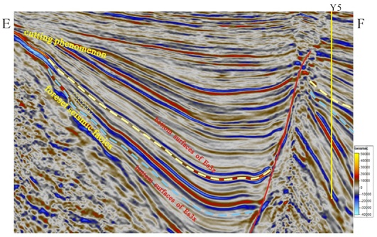
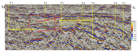 Figure 4: Seismic profile of Y2 well and Y5 well (other well locations are projection wells) (Xline1890).
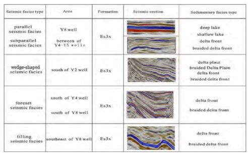 Figure 5: Regional seismic legend of the study area.
Parallel to the horizontal seismic facies: In the study area, it mainly distributed in the central of Y3 well, Y4 well and Y5 well. Internal reflection structure is high amplitude, high continuity, nearly parallel to the shape characteristic. The seismic reflection external form for sheet, the lower level is parallel or nearly parallel to the contact, the thickness of relatively stable. And the lithology mainly mudstone purpose layer, sand ratio is less than 0.2 by analyzing core samples, it reflecting the weak hydrodynamic conditions of deposition as a result, reflects the uneven subsidence of delta platform characteristics
Foreset seismic facies: The front end of the foreset reflection layer presents a downward superstate toward the pelvic floor, while the proximal end presents a top superstate toward the basin edge. The wedge-shaped foreset in the study area is characterized by wedge-shaped distributionalong the same direction axis and forward accretion. It is mainly distributed in the south of Y4 well and Y8 well. According to the logging data of Y8 well, it indicates the fan delta deposition on the slope
Wedge-shaped seismic facies: The whole profile is wedge-shaped, and the internal reflection features are composed of medium-strong amplitude and medium-high continuous reflection in the same phase axis, which is the result of different settlement and deposition rates around the lake basin. In the study area, it is mainly distributed in the southwest of Y2 well and located in the slope belt. According to the results of coring interval calibration, the wedge-shaped seismic facies in this area belongs to the sedimentary seismic response of braided river delta
Filling phase: It is characterized by filling shape of the unit. There are two facies in gulch filling phase: open filling (low-energy environment) and partial filling (high-energy environment), the filling in the study area for filling deposit in valleys. In the seismic section, in local dent, rendered in valleys. For the waveform characteristics of the region, medium strong amplitude and continuity well and parallel reflection can be found. It mainly reflect the shore and shallow lake, half deep lake, braided delta and delta front sedimentary environment
Seismic attribute analysis
Under the guidance of seismic sedimentology, the target layer properties are accurately extracted. Appropriate time window layer is selected to extract seismic attributes, and seismic attributes are used to identify the planar distribution characteristics of the sedimentary system, and the sensitivity of the sedimentary system to seismic attributes is comprehensively considered to determine the characteristics of seismic facies [11]. We extracted RMS (root-mean-square) amplitude, mean instantaneous frequency and other attributes for analysis. Finally, it was found that the root-mean-square amplitude attribute had a guiding effect on the sedimentary plane distribution in the study area. By extracting the seismic attributes of RMS amplitude in Es3x formation in the 3D- seismic working area of the study area, it is found that there is a strong amplitude area in the south and southeast area of the study area (Figure 6ii), indicating that sand bodies in these areas are relatively developed and may be the main developed area of the delta. In the western part of the study area (Figure 6i), there is a band of mid-strong amplitude area, which is presumed to be braided river delta deposition. In the central area of the depression, that is, the south of Y8 well and around the northeast (Figure 6iii) are all weak amplitude areas, indicating that these areas are lake mudstone sedimentary areas and lacustrine sediments.
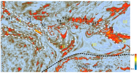 Figure 6: Root-mean-square amplitude attribute map of Es3x Formation.
SEDIMENTARY DISTRIBUTION CHARACTERISTICS OF ES3X FORMATION
Conversion of seismic and sedimentary facies
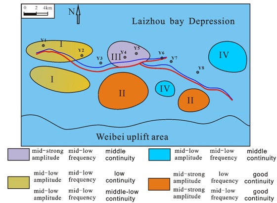
According to the plane distribution characteristics of seismic facies in the study area and combined with the regional sedimentary environment [12-15], the corresponding transformation relationship between seismic facies and sedimentary facies was constructed (Table 1).
|
Phase type |
Facies marks |
Area |
|
|
mixed sedimentary platform |
parallel subparallel seismic facies |
mid-low frequency mid-strong amplitude middle continuity |
III |
|
mid frequency mid amplitude middle continuity |
|||
|
braided river delta |
wedge-shaped seismic facies |
mid-low frequency mid amplitude middle continuity |
I |
|
low frequency mid-low amplitude low continuity |
|||
|
fan delta |
foreset seismic facies |
mid-low frequency mid-low amplitude low continuity |
II |
|
mid frequency mid-low amplitude middle-low continuity |
|||
|
mid frequency strong amplitude good continuity |
|||
|
low frequency low amplitude middle-low continuity |
|||
|
shore shallow lake |
parallel subparallel seismic facies |
mid-low frequency mid-low amplitude middle continuity |
IV |
|
low frequency mid-low amplitude good continuity |
|||
Single well phase analysis
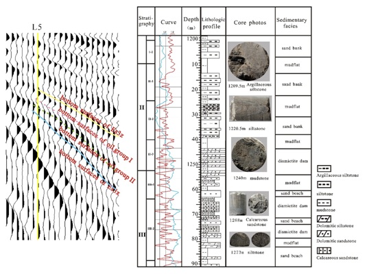
From single well can be found in the phase diagram, III-2 of oil group to II-2 of oil group deposit gray powder sandstone with thin layers of mudstone, through the core can be found in the development of cross-bedding, wedge cross bedding, wavy bedding and other bar sedimentary characteristics, response on seismic profile characteristics of weak amplitude, medium-low frequency, medium continuously. II-1 of oil group to I-2 of oil group deposit thin layer powder sandstone and argillaceous siltstone with a large set of mudstone. Bioclastic can be found in the core photos. Sedimentary characteristics have parallel bedding, tabular and trough cross-bedding delta front. Waveform response on seismic profile for weak amplitude, low frequency, medium continuously; According to the lithologic combination characteristics, there are both carbonate rocks and terrigenous clastic rocks, it can be judged that the Y5 well area has mixed sedimentary morphology, which reveals the characteristics of the sand body being transformed by waves, and it is the lakeside sedimentary environment with shallow water.
It is found that the braided river delta deposits from the far Kendong uplift are developed in the western Y2 well area, while the fan delta deposits from the Weibei uplift are mainly developed in the eastern Y6-Y7-Y8 wells area. However, affected by the bottom uplift and faults, Y3-Y4-Y5 wells in the middle blocks the source materials from the Kendong and Weibei uplift and deposits the mixed sediments belonging to lacuvial facies (Figure 9).
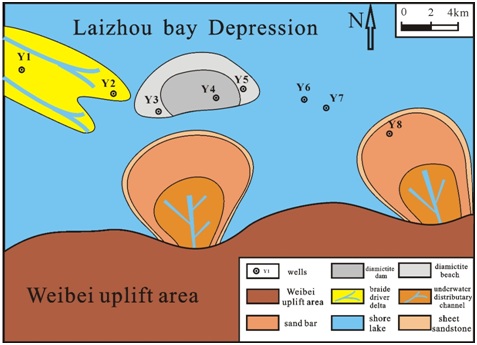 Figure 9: Sediment map of Es3x formation in southern region.
DISCUSSION
Distribution of sedimentary facies
Distribution of seismic facies
CONCLUSION
2. According to the sedimentary environment, analysis of seismic profiles, seismic facies analysis, seismic attribute analysis, the study area in southern and eastern Y6-Y7-Y8 wells area of fan delta sedimentary facies, provided source by Weibei uplift. The study area in western Y2 well area is braided river delta sedimentary facies, provide source from Kendong uplift. Central Y3-Y4- Y5 wells area is affected by the bottom uplift raised for similar platform, sedimentary lacustrine peperite
REFERENCES
- Yanlei D, Yumin Z, Dejiang L, Jun-sheng Y, Yu-yin Z, et al. (2007) Seismic facies of Paleogene in Liaodong Bay area, Bohai Bay Basin.ActaSedimentologicaSinica 4: 554-563.
- Wenchao L, Guokun Z, Hongfei Y, et al. (2018) Mixed sedimentary characteristics and developmental patterns of the Paleogene in the southern Laizhou Bay Sag, Bohai Sea. Journal of Palaeogeography 20: 1033-1042.
- Ruijie X (2008) Study on sequence stratigraphy and sedimentary facies of the lower member of Shahejie Formation in Minfeng area, Dongying Sag. Lithologic Reservoirs 20: 39-43.
- Yonggang W, Youxi L, Junhua Z (2006) Seismic attribute analysis technology. Beijing: China University of Petroleum Press.
- Gaiwei W, Xiaofeng D, Donghui J, Qiming W, Jifeng D (2015) High-precision sequence stratigraphic framework and sedimentary system evolution in the middle third member of Shahejie Formation, Laizhou Bay Sag. Sedimentary and Testi Geology 35: 17-24.
- KhalifaMK,Mills KJ, Hlal O(2016) Seismic stratigraphic interpretation of megasequence and sequence framework in the Upper Cambrian through Devonian formations in the central part of the Darling Basin, western New South Wales, Australia. Marine and Petroleum Geology 77: 668-692.
- Ghani H (2009) Structural and stratigraphic interpretation of seismic data of joyamair area chakwal,Pakistan. Earth Science Frontiers16: 215.
- Xiaoping W, Bo C, Guang Z, Quan L, fragrance N (2008) Application of seismic facies analysis technique to sedimentary characteristics analysis of Yitong mantle reservoir. Petroleum Geophysical Prospecting 2: 172-178.
- Lei L, Ying-min W, Zhi-chao H, Ya-hong R, Lian-mei Z (2008) Sequence stratigraphy and seismic facies study in the deep waters of the Niger Delta. ActaSedimentologicaSinica 3: 407-416.
- Zunde C, Fugui Z (1998) Attribute optimization method in seismic data oil and gas prediction. Geophysical Prospecting for Petroleum 37: 32-40.
- XiannaZ (2017) Research on multi-attribute joint inversion reservoir seismic prediction method. Jilin University, Changchun, China.
- Gang G, Shangru Y, Tong Q (2018) Current status of mixed deposition research and its relationship with oil and gas enrichment. Geological Science and Technology Information 37: 82-88.
- Maosong Y,Xiong J, Changgui X, Xiaofeng D, Zhangqiang S, et al. (2018) Discussion on classification and naming system of mixed rock and its implications for evaluation of mixed rock reservoirs: A case study of mixed rock in Bohai Sea. Geological Review 64: 1118-1131.
- Jinliang Z, XueqiangS (2007) Mixed sedimentation of carbonate and terrigenous clastics in faulted basin: A case study of the upper member of the fourth member of the Shahejie Formation of the Paleogene in Jinjia area, Dongying depression.Geological Review 4: 448-453.
- Lei H, Qiang W, Qiang W, Qiang W (2012) Evolution of the Cenozoic basin in the Laizhouwan Sag, Bohai Bay Basin. Chinese Journal of Geology, 86: 867-876.
Citation: Xudong Y, Jun X, Liang Z, Mengqi W, Xinyu J (2019) Seismic-sedimentary Facies Analysis of Es3x Formation in Southern Region, Laizhou Bay Depression, Bohai Bay Basin, China. J Atmos Earth Sci 3: 011.
Copyright: © 2019 Yang Xudong, et al. This is an open-access article distributed under the terms of the Creative Commons Attribution License, which permits unrestricted use, distribution, and reproduction in any medium, provided the original author and source are credited.